


The Complete Guide to the Machu Picchu Mountain Range: Peaks, Hikes & History
Come on admit it; when people say, “I’m going to Machu Picchu,” what they’re visualizing is the stone city, the llamas, and that iconic postcard shot. However, it’s better understood – and more vibrant – as a mountain tale.
So here’s the question that pops up in a lot of trip-planning chats (and group texts): what mountain range is Machu Picchu located in? The short, clean answer: The Andes. In particular, it is located in the Vilcabamba range (also known as Cordillera de Vilcabamba), a mountainous zone within the Andes mountains in southern Peru. And, right there up on a narrow ridge over the Urubamba River, the Inca created a city that looks like it’s up in the clouds.
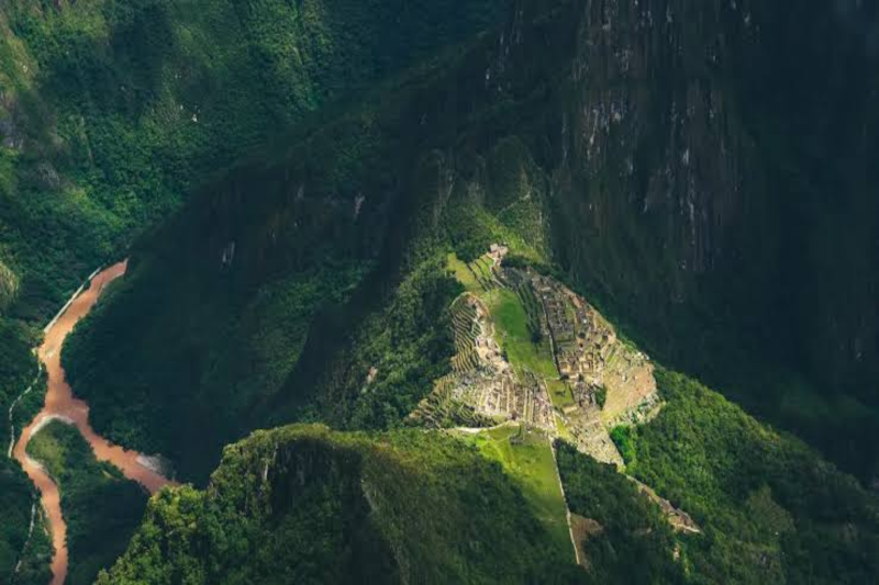
So, is it a “mountain range” or just a few peaks?
Both, kind of. People say “Machu Picchu mountain range” as a handy label for the cluster of steep peaks around the site. Locally and on maps, you’ll usually see the Andes and the Vilcabamba range mentioned more than “Machu Picchu range.” Either way, when you stand there, the geography does the talking.
The mountain behind the ruins (Huayna Picchu in photos) and the mountain in front of the ruins (Machu Picchu Mountain) are two renowned peaks that lie at either side of Machu Picchu. The city is not situated on a level plain. It’s on a ridge. That choice wasn’t random—it was a risk-managed layout before “risk management” was a job title.
The landscape has a split personality (and that’s the magic)
The thing is that you are in the Andes and close to the Amazon basin. Kinda weird and supercool and super funky—cool mountain air one minute, warm jungle breath the next. It is sometimes called cloud forest and that is because the first time the mist goes through the Trees like slow smoke you’ll understand the meaning of the term.
You’ll notice the microclimates fast. Step into the sun. Then shade. Then a light drizzle. Then sun again. It’s like the weather has multiple tabs open and keeps switching.
All round this place doesn’t have to try too hard to impress you with its natural aspects: the orchids on a rock, colorful birds darting about the trail, and plants like you’d find in a science museum. This also means you will sometimes see llamas. They don’t say much, but they are the local force of untrained security, and they don’t like you being at their property.

Wait—why did the Inca build there?
This is where the “project plan” angle shows up. Building on a ridge with steep slopes is a headache. And yet, it solved problems.
Defense: the terrain is naturally hard to reach.
Water: springs run through the area, and the Inca engineered channels to move water where it needed to go.
Farming: those terraces weren’t only pretty. They were a food system and a slope-stabilizing system at the same time.
People love to say it was all spiritual. Sure—there’s strong evidence the site had religious meaning. But it’s also practical. And that mix feels very human, doesn’t it? Big beliefs, but still worried about erosion and storage.
Stonework that still makes engineers squint
You don’t need to be an architect to feel it: the stone walls look tight. Like, no gaps tight. The INCAs were able to shape stones to such an exquisite degree that the blocks fit together without being masonry. This is helpful during earthquakes as the resulting earthquake-induced rock motion can adjust a little rather than cracking brittle concrete.
There is drainage at Machu Picchu and this is also something that comes across in your racing quite easily when you are busy putting in images (second or third view already taken). Rain is common here. So under the terraces and plazas, there’s layered stone and gravel that lets water pass through. Think of it as a giant, built-in “stormwater system,” except it’s made of rocks and patience.
There’s a reason civil engineers visit and nerd out a bit. The site is a case study, but it’s also oddly emotional. You’re looking at problem-solving that survived centuries.
Let’s talk Machu Picchu hikes (because the trails are half the point)
If you like walking through a place instead of only looking at it, the hikes here feel like a reward. Some are famous. Some are quieter. Most involve stairs—lots of stairs.
The Classic Inca Trail: the “iconic” choice (with paperwork)
The Classic Inca Trail is legendary for a reason. You move through ruins, forest, and high passes, and you arrive on foot the way travelers did long ago. But it’s also capped and controlled, which means you need a permit through a licensed operator.
Planning note, in plain terms: if you’re aiming for peak season (May to September), book months ahead. If you’re more of a “let’s see how we feel” traveler, you’ll want a backup plan.
Salkantay Trek: tougher, wilder, and very worth it
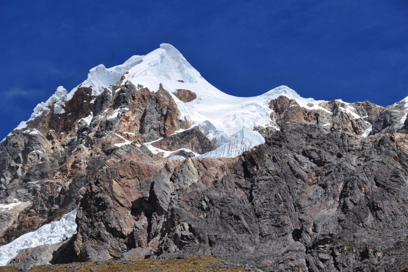
The Salkantay Trek is often pitched as the alternative, but it’s not a consolation prize. It’s a big route with big scenery. You cross high mountain zones and then drop into warmer, greener terrain. Your legs will notice.
Can beginners do it? Yes—if you train and take acclimatization seriously. No technical climbing, but the altitude can be the real boss fight.
Small digression that matters: if you track workouts, you’ll probably love how hiking here feels like a real “performance” day. If you don’t track workouts, you’ll still love it, because your brain stops buzzing after a few hours on a trail. It’s hard to worry about email when you’re counting steps and watching clouds roll over a ridge.
Inside the site: Huayna Picchu vs. Machu Picchu Mountain
After arriving at the citadel, there is a classic choice of who to climb Huayna Picchu or Machu Picchu Mountain.
The Huayna Picchu is rugged and steep. As the trail descends it is narrow and parts of it are exposed. It’s exciting… and a little spicy if you hate heights.
Machu Picchu Mountain takes longer and climbs higher, but the path is usually wider. The payoff is a broad view of the whole area—the ruins, the river curve, the peaks. It’s less “white-knuckle,” more “slow burn.”
Both require timed tickets. And yes, they sell out. This is one of those moments where planning beats optimism.
The question people keep asking: “Will I get altitude sickness?”
Maybe. That’s the honest answer. One of the reasons you usually need to spend a couple of days acclimatizing in Cusco or the Sacred Valley is that Cusco is higher than Machu Picchu. It’s sort of like welcoming your body on the job! Allow for adjustment, water and gradually get used to the intensity of hard work. Many travelers try coca tea (it’s common in Peru). Some carry medication prescribed by their doctor. Either way, the main move is simple: don’t rush day one.
Here’s a mild contradiction: you can be “fit” and still feel rough at altitude. Fitness helps, but oxygen is a separate problem. If you’ve ever flown to a new time zone and felt off, it’s a similar vibe—your system needs a moment to catch up.
Getting there: the logistics are part of the story

Machu Picchu is no ordinary by-pass. The majority of travellers make the journey from Cusco to Ollantaytambo and end up by train to Aguas Calientes (also known as Machu Picchu Pueblo). Train brands like PeruRail and Inca Rail run the route, and the ride is scenic in that “why does my camera roll have 80 river photos?” way.
Budget route? Some people go to Hidroelectrica and walk along the tracks to town. It’s flatter than the big treks, but it’s still a real walk. And it’s a reminder that “cheap” often means “more time.”
Once you’re in Aguas Calientes, you’ll either bus up to the entrance or hike up (steep, early, humid). Either choice works. It depends on your energy budget—and whether your knees file complaints.
When to go (and how the seasons mess with your plans)
The dry season, roughly May through September, gives you the highest odds of clear views. It’s also the busiest. Shoulder months can be a sweet spot: fewer crowds, decent weather, and a calmer feel on the paths.
Cloudy skies and slippery steps may be a feature of rainy season (from about November to March). It can also result in greener hills, moody fog and the feeling that the ruins beam out of their habitat.If you’re the type who likes atmosphere more than perfect skies, don’t write it off.
And a quick modern-trend aside: people are traveling with “content plans” now—photos, reels, drone shots (drones aren’t allowed at the site), all of it. That’s fine. Just remember the place is better when you give it a few minutes without a lens in front of it. You’ll feel the scale more. Your shoulders might drop. It happens.
What to pack (not a spreadsheet, I promise)
Packing for the Machu Picchu mountain range is a bit like packing for a day that can’t commit. Cool mornings, warm afternoons, sudden rain. Layering is the smart play.
- Broken-in hiking shoes: grippy soles help on stone steps.
- Light rain jacket: the mist can turn into real rain fast.
- Warm layer: mornings can feel sharp.
- Sun protection: hat, sunglasses, sunscreen. High altitude sun is no joke.
- Water + snacks: steady energy beats heroic energy.
- Offline maps: apps like AllTrails or Gaia GPS are handy (download ahead).
Also: bring patience. Lines happen. Rules change. Tickets have time windows. It’s not chaotic, but it’s not frictionless either.
Why this place sticks with you (even after the photos fade)

By the time you leave, you’ll probably have a favorite moment. It might be a big one—sunrise over the ruins. Or something small—hearing water run through a stone channel, or catching the scent of wet earth after a quick shower of rain.
And maybe that’s the real point of exploring the Machu Picchu mountain range. The mountains aren’t background. They’re the main character, and the city is the bold plot twist sitting right in the middle.
So yes, Machu Picchu is located in the Andes, in the Vilcabamba range. That’s the geography answer. But the lived answer is simpler: it’s a place where the land and the people who shaped it still talk to each other. Quietly. Clearly. If you listen.